Powerful Quake Hits Philippines, Tsunami Alert Issued
A major seismic event has rocked the southern Philippines, with a powerful quake hitting the Philippines, triggering a tsunami alert across coastal areas and surrounding regions. Initial reports confirm a magnitude 7.8 earthquake struck off the coast of Mindanao, prompting immediate and urgent warnings from national disaster agencies. Residents in low-lying coastal zones have been advised to evacuate immediately as authorities assess the potential for destructive waves following this significant geological event. The swift issuance of the tsunami alert underscores the severity of the situation and the critical need for rapid community response.
- Powerful Quake Hits Philippines, Tsunami Alert: Initial Reports and Magnitude
- Tsunami Warnings Issued
- Immediate Aftermath and Damage Assessment
- Government and International Response
- Historical Precedents and Preparedness
- Long-Term Outlook and Recovery Challenges
- Conclusion
- Frequently Asked Questions
- Further Reading & Resources
Powerful Quake Hits Philippines, Tsunami Alert: Initial Reports and Magnitude
Early reports from the Philippine Institute of Volcanology and Seismology (PHIVOLCS) indicate the powerful earthquake registered a magnitude of 7.8 on the Richter scale. The epicenter was located approximately 100 kilometers southeast of Davao Oriental, at a relatively shallow depth of 30 kilometers beneath the seabed. This shallow depth is a critical factor, as it often results in more intense ground shaking and a higher potential for significant damage. Tremors were felt across a wide swath of the southern Philippines, including major cities like Davao City, General Santos City, and even parts of the Visayas region. Residents described prolonged and violent shaking, leading to widespread panic in urban centers. Initial assessments suggest that the earthquake's intensity at its epicenter reached VIII on the PHIVOLCS Earthquake Intensity Scale (PEIS), indicating "very destructive" shaking.
Geological Context of the Philippines
The Philippines is situated along the notorious "Pacific Ring of Fire," a horseshoe-shaped belt around the Pacific Ocean characterized by frequent earthquakes and volcanic eruptions. This geological hotbed is a result of the collision and subduction of several major tectonic plates, including the Philippine Sea Plate and the Eurasian Plate. The complexity of these interactions leads to numerous active fault lines crisscrossing the archipelago, making it one of the most seismically active regions globally. Historical records are replete with instances of devastating earthquakes and tsunamis that have impacted the nation. Understanding this geological context is crucial for comprehending the persistent seismic risk faced by the Philippines, a nation constantly grappling with the geological risks of the Pacific Ring of Fire.
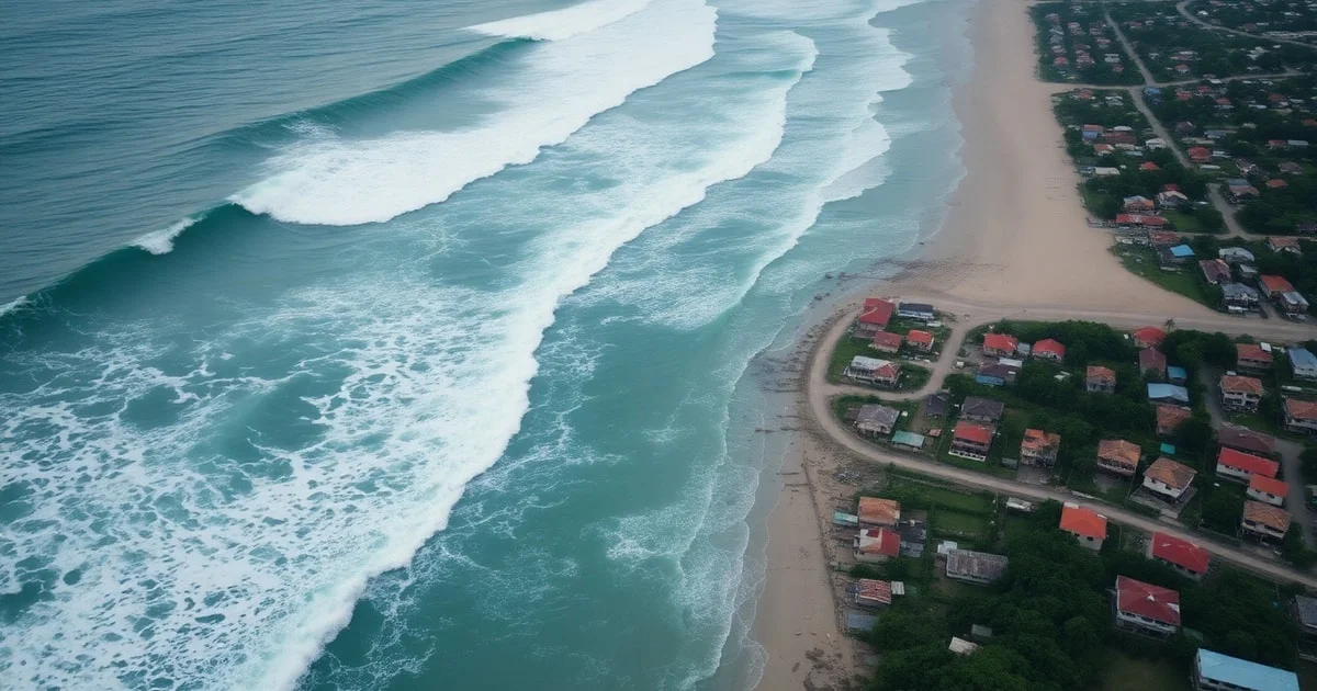
Tsunami Warnings Issued
Following the powerful tremor, national disaster agencies, in coordination with the Pacific Tsunami Warning Center (PTWC), promptly issued a tsunami alert. The alert specifically targeted coastal areas in Mindanao, particularly those facing the Philippine Trench, where the seismic activity originated. PHIVOLIVCS warned of potential tsunami waves ranging from 1 to 3 meters (3 to 10 feet) that could impact shorelines within hours of the quake. Local government units immediately activated their disaster preparedness protocols, urging residents in identified high-risk coastal communities to move to higher ground. The swift dissemination of these warnings is paramount in minimizing potential casualties.
Regional Tsunami Advisories
The impact of such a powerful subsea earthquake is not confined to the immediate vicinity. Regional tsunami advisories were also extended to neighboring countries and territories in the western Pacific. These included advisories for parts of Indonesia, Palau, and Malaysia, particularly those with coastlines susceptible to waves traveling across the Celebes Sea and the Philippine Sea. While the threat level for these regions was generally lower than for the direct impact zones in the Philippines, authorities maintained a high state of vigilance. International maritime traffic was also advised to exercise extreme caution in affected waters. The interconnectedness of tectonic plates means that a major seismic event in one area can have ripple effects across an entire oceanic basin, necessitating broad-scale alerts and coordinated international responses.
Immediate Aftermath and Damage Assessment
As dawn breaks over the affected regions, the full extent of the damage is slowly becoming apparent. Initial reports indicate significant structural damage in towns closer to the epicenter, with several buildings reportedly collapsing and roads developing cracks. Power outages have been widespread across Mindanao, complicating communication and rescue efforts. Hospitals in Davao City and General Santos City are reporting an influx of patients with minor injuries sustained during the panic and evacuation. Fortunately, early indications suggest that effective public advisories and quick evacuation procedures may have mitigated a larger-scale catastrophe, particularly regarding tsunami impact. However, search and rescue operations are still in their nascent stages, and authorities are working diligently to reach remote areas.
Eyewitness Accounts and Local Impact
The human toll of the earthquake is palpable, even in its early assessment. Eyewitnesses describe scenes of sheer terror as the ground shook violently. "It felt like the world was ending," recounted Maria Santos, a resident of Mati City, Davao Oriental, whose house sustained significant cracks. "We immediately grabbed our children and ran to the hills. The tsunami warning made us even more frantic." Many families spent the night in designated evacuation centers, anxiously awaiting news and updates. The psychological impact on communities accustomed to seismic activity but rarely experiencing such intense shaking will be profound. Children, in particular, may require specialized support to cope with the trauma of the event. Local fishing communities, whose livelihoods depend on the sea, are also deeply concerned about the potential damage to their boats and coastal infrastructure. The uncertainty of the aftermath adds to the widespread anxiety.
Government and International Response
The Philippine government has swiftly mobilized its national disaster response mechanisms. President Ferdinand Marcos Jr. has ordered all relevant agencies, including the National Disaster Risk Reduction and Management Council (NDRRMC), the Philippine Coast Guard, and the Armed Forces of the Philippines, to prioritize search and rescue, damage assessment, and humanitarian aid efforts. Emergency response teams, equipped with search-and-rescue dogs and specialized tools, are being deployed to the hardest-hit areas. The Department of Social Welfare and Development (DSWD) is already preparing relief goods and establishing temporary shelters for displaced families. Several international organizations and neighboring countries have also extended offers of assistance, including medical teams, financial aid, and logistical support, highlighting global solidarity in disaster relief.
Evacuation Procedures and Safety Protocols
In the wake of the tsunami alert, adherence to evacuation procedures has been critical. Local authorities meticulously identified safe zones and evacuation routes, often leading to higher ground away from the coast. Community leaders utilized sirens, loudspeakers, and social media to disseminate real-time information and instructions. Residents were urged to remain calm, follow official directives, and avoid returning to coastal areas until "all clear" signals were issued by PHIVOLCS. Emphasis was placed on ensuring the safety of vulnerable populations, including the elderly, children, and persons with disabilities, during the evacuation process. These established protocols, honed through years of experience with natural disasters, proved invaluable in managing the initial chaos.
Historical Precedents and Preparedness
The Philippines has a long and often tragic history of powerful earthquakes and tsunamis. One of the most devastating was the 1976 Moro Gulf earthquake and tsunami, a magnitude 8.0 event that claimed thousands of lives. Such historical precedents have profoundly shaped the nation's approach to disaster preparedness. Over the decades, significant investments have been made in early warning systems, seismic monitoring networks, and public education campaigns. Regular earthquake and tsunami drills are conducted in schools and communities, aiming to instill a culture of readiness. These preparedness measures, while never perfect, are continuously refined to better protect the population from the inevitable geological forces at play, emphasizing the importance of comprehensive disaster preparedness strategies.
Advancements in Early Warning Systems
Technological advancements have revolutionized the ability to detect and warn about seismic events and impending tsunamis. Modern seismic networks utilize real-time data streaming from seismographs strategically placed across the archipelago and underwater sensors. This data is fed into sophisticated computer models that can rapidly calculate earthquake magnitudes, epicenters, and potential tsunami wave propagation. The Philippine Tsunami Warning System (PTWS), managed by PHIVOLCS, integrates this data with international partners like the PTWC to issue timely alerts. Furthermore, public dissemination has improved dramatically, leveraging SMS alerts, social media, and dedicated mobile applications to reach a wider audience almost instantaneously, showcasing the evolution of early warning systems in disaster management. These systems are a critical first line of defense, buying precious minutes for evacuation.
Long-Term Outlook and Recovery Challenges
The long-term recovery following an event of this magnitude presents substantial challenges. Rebuilding damaged infrastructure, including homes, roads, and utilities, will require significant resources and time. Economic disruption, particularly in coastal communities reliant on fishing and tourism, is inevitable. The psychological toll on survivors will also necessitate sustained support and mental health services. The government, in collaboration with non-governmental organizations and international aid partners, will need to develop comprehensive recovery plans that address both immediate needs and sustainable reconstruction. Ensuring resilient infrastructure that can withstand future seismic events will be a key consideration in the rebuilding process. Climate change also adds another layer of complexity, as sea-level rise can exacerbate the impact of future tsunamis.
Psychological Impact on Communities
Beyond the physical destruction, the psychological impact of a powerful earthquake and tsunami threat can be profound and long-lasting. Communities that have experienced such a traumatic event often grapple with anxiety, post-traumatic stress disorder (PTSD), and a pervasive sense of insecurity. Children are particularly vulnerable and may exhibit behavioral changes or developmental setbacks. Providing accessible mental health support, including counseling and community-based psychosocial interventions, is crucial for helping affected populations heal and rebuild their emotional well-being. Local support networks, traditional healing practices, and community resilience programs play a vital role in this recovery process, fostering a sense of solidarity and collective healing.
Conclusion
The recent powerful quake hitting the Philippines, triggering a tsunami alert, serves as a stark reminder of the nation's vulnerability to natural disasters. While the immediate focus remains on search and rescue, damage assessment, and providing humanitarian aid, the event also highlights the ongoing importance of robust disaster preparedness and early warning systems. The resilience of the Filipino people, coupled with sustained efforts in mitigation and response, will be critical in navigating the aftermath and rebuilding stronger communities. As the situation evolves, vigilance and adherence to official advisories remain paramount for all affected residents. The international community stands ready to offer support, underscoring the global solidarity in the face of such formidable natural challenges.
Frequently Asked Questions
Q: What was the magnitude of the earthquake that hit the Philippines?
A: The powerful earthquake registered a magnitude of 7.8 on the Richter scale. Its epicenter was located approximately 100 kilometers southeast of Davao Oriental at a shallow depth of 30 kilometers.
Q: Why is the Philippines prone to earthquakes and tsunamis?
A: The Philippines is situated along the "Pacific Ring of Fire," an active seismic zone caused by the collision and subduction of several major tectonic plates. This geological activity results in frequent earthquakes and a high risk of tsunamis.
Q: What immediate actions were taken after the tsunami alert?
A: National disaster agencies issued immediate tsunami alerts for coastal areas, urging residents in high-risk communities to evacuate to higher ground. Local government units activated preparedness protocols and disseminated real-time safety instructions.